Imagine watching the weather forecast, palm sweating as anchors warn of an incoming hurricane. Sometimes they get it exactly right. But often, something happens no supercomputer or satellite could see coming—a storm explodes in strength, a stubborn heat wave drags on for weeks, or rain pours far longer than models predicted. Even with all our technology and brainpower, there are still moments when the atmosphere throws us a puzzle too complex to solve.
How can that be? If you’re like me, you might think that with so many satellites, weather balloons, and AI crunching numbers, surprise hurricanes or rogue tornadoes should be a thing of the past. But five mysteries still keep meteorologists guessing—and sometimes, on the edge of their seats.
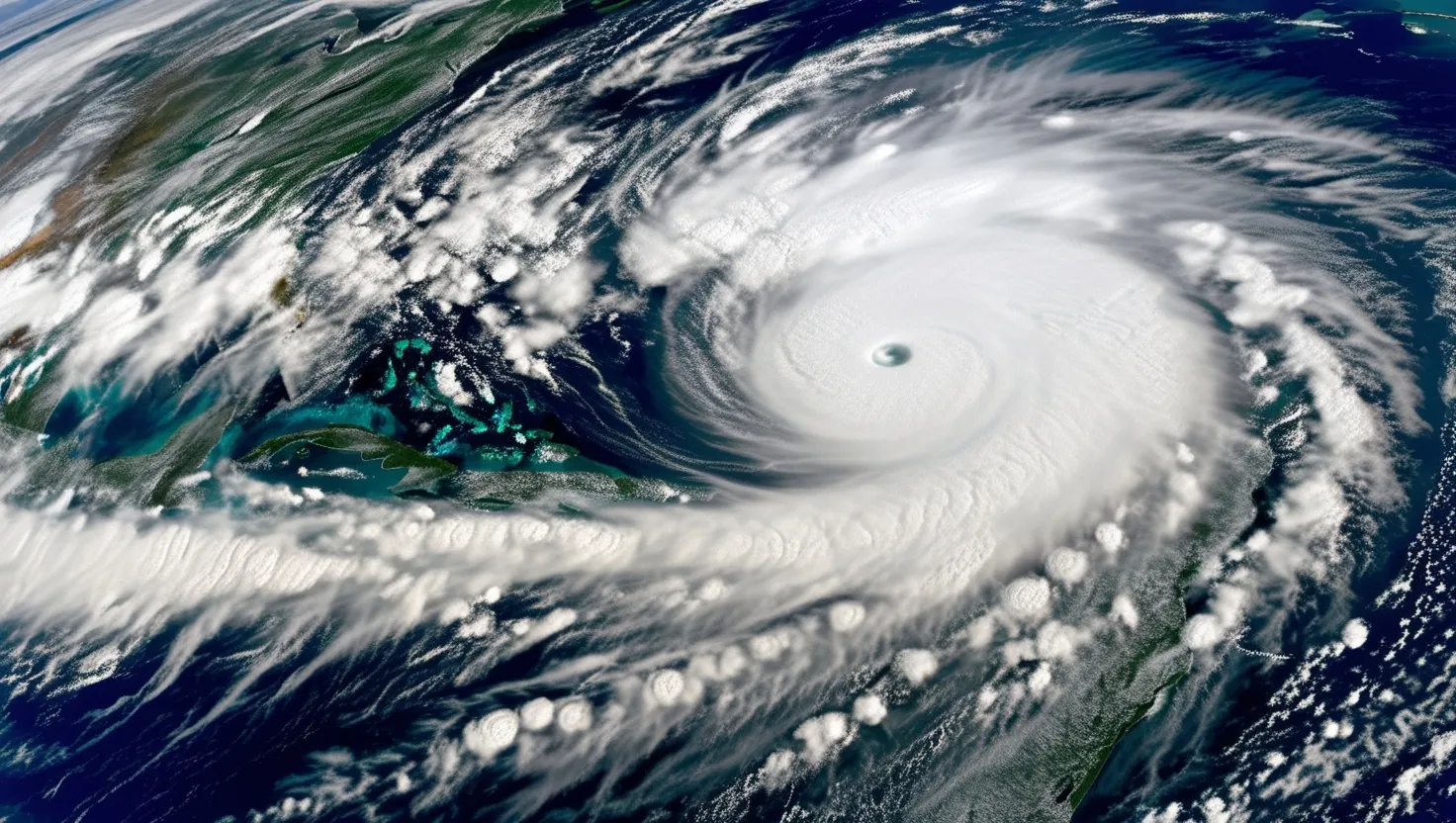
Rapid hurricane intensification is a prime example. We can track a tropical depression churning in the Atlantic for days, feeding hurricane models countless weather data points. Yet sometimes, almost out of nowhere, wind speeds soar, and a mild storm becomes a monster overnight. This has serious consequences. A coastline that expects a Category 1 storm might suddenly be staring down a Category 4 before anyone can make necessary preparations. The big question is: why do only some hurricanes experience this turbocharged growth? Is it a hidden patch of blazing ocean water, secret gusts of dry air, or something even smaller, swirling at scales our satellites can’t catch? Even the best models can be caught flat-footed. As Isaac Newton once said, “What we know is a drop, what we don’t know is an ocean.” In extreme weather, that still feels true.
Let me ask you to reflect: the last time you saw a major hurricane surprising everyone, did you wonder whether our technology was asleep at the wheel, or is the atmosphere just playing by its own rules?
Then there’s the riddle of atmospheric blocking patterns. These invisible walls of high pressure sometimes stall over a region, refusing to budge for weeks. That can mean relentless heat, drought, or conversely, stubborn downpours and flooding. Scientists call them “blocking highs.” The cause? Not so simple. Sometimes, a wobble in the jet stream gets stuck. Other times, distant ocean currents or even mountain ranges may play a silent part. I find it remarkable that our forecasting models can see these patterns sometimes, but still can’t reliably say why they stick or why they end. Imagine trying to plan for next summer, knowing your city could be roasting under a heat dome or spared entirely—and you have almost no way to know how or why.
There’s a famous quote by meteorologist Edward Lorenz: “The flap of a butterfly’s wings in Brazil can set off a tornado in Texas.” This captures the stubborn unpredictability in atmospheric science, especially when it comes to tornadoes.
Which leads me right to our next mystery: the trigger for tornadogenesis. We have a pretty good recipe for tornado formation—warm, moist air, instability, and a rotating updraft called a mesocyclone inside a supercell. But what flips the actual “on” switch? Most powerful storms never spawn a tornado, and even when they do, predicting the exact place and time remains frustratingly hard. The missing ingredient? It hides at scales smaller than most of our observing technologies can see—tiny circulations, boundary layers of air just a few meters deep, perhaps even subtle differences in soil moisture or terrain. With all of our Doppler radar and AI, we’re left watching in real time, sometimes just minutes before a funnel drops. Are we missing something fundamental, or are there truly random processes built into storm physics?
Pause and think for a moment: if you lived in “Tornado Alley,” would you rather have more false alarms or risk missing the warning entirely?
Heat domes add another layer of complexity. These massive bubbles of stifling, trapped air bend weather around them, leading to record temperatures, blistering heatwaves, and health crises. The term “heat dome” sounds straightforward, but the forces that create these phenomena are complicated and deeply intertwined. Ocean temperatures, shifting winds far above the ground, and even patches of urban concrete can play a role. Sometimes, a slight adjustment in the jet stream can cause a heat dome to blow up over one continent while leaving another untouched. What’s surprising is that our best climate models still struggle to simulate the precise conditions that spark these domes, making it tough to prepare for or mitigate their impacts. It raises the question: could subtle clues—perhaps in seemingly unrelated corners of the earth—hold the secret to predicting when and where the next heat dome will emerge?
As physicist Richard Feynman once advised, “I would rather have questions that can’t be answered than answers that can’t be questioned.” The heat dome mystery fits squarely into this philosophy—every answer we get breeds more questions.
But perhaps the most peculiar of all is the “brown ocean” effect. Most people assume hurricanes collapse as soon as they move over land—their oceanic fuel gone, they should simply fizzle out. But sometimes, storms maintain their punch or even intensify inland. The secret: saturated soils can provide enough moisture to keep a storm’s engine running, just as if it were still over water. But what does “saturated enough” mean? Is it a specific soil type, the presence of standing water, or some weird combination with local weather conditions? Researchers are only beginning to scratch the surface of this phenomenon. The brown ocean effect can catch communities by surprise, leading to flooding or wind damage in places that think themselves safe once a storm crosses the shoreline. Isn’t it odd to think that freshly soaked farmland could rival the Atlantic, at least in the eyes of a storm?
All this uncertainty reveals a striking truth—extreme weather is less a series of isolated thermodynamic puzzles and more like a conversation with a system that is always in motion, always reacting to itself. Our forecasting models are like educated guesses in a game with moving rules. That’s not to say we make no progress. Short-term weather forecasts today are more accurate than at any point in history. We can spot major storms days out, and our warnings save countless lives. But when it comes to the details—the rapid intensification, the perfectly placed block, the exact moment a tornado will drop—the atmosphere keeps its secrets, daring us to look closer.
When I think about these mysteries, I realize forecasting will probably never be perfect. The beauty of the weather is that it defies prediction just as often as it meets our expectations. Would the world be less interesting if our forecasts came with no uncertainty, and every sunny day, storm, and snowflake arrived right on schedule?
As William Shakespeare once wrote: “The heavens themselves, the planets, and this center observe degree, priority, and place…” and yet, as we know, the chaos in the skies so often resists neat order and prediction.
Perhaps the challenge is what makes extreme weather one of the last wild territories in modern science. For as long as we chase rain clouds and hurricane eyes, we’re also chasing an understanding of nature’s complexity that — for now — stays just beyond the next forecast. The questions left unanswered are not signs of failure, but invitations to keep asking, keep watching, and keep wondering at a world where, even in the age of smart tech, some surprises simply refuse to be seen ahead of time.
So the next time a storm surprises us, don’t just curse the forecast. Remember how many layers lie behind that missed prediction. And, maybe, ask yourself: could the real story of extreme weather be in what we’re still learning—not just in what we think we already know?